Valle, Aust-Agder, Norway
|
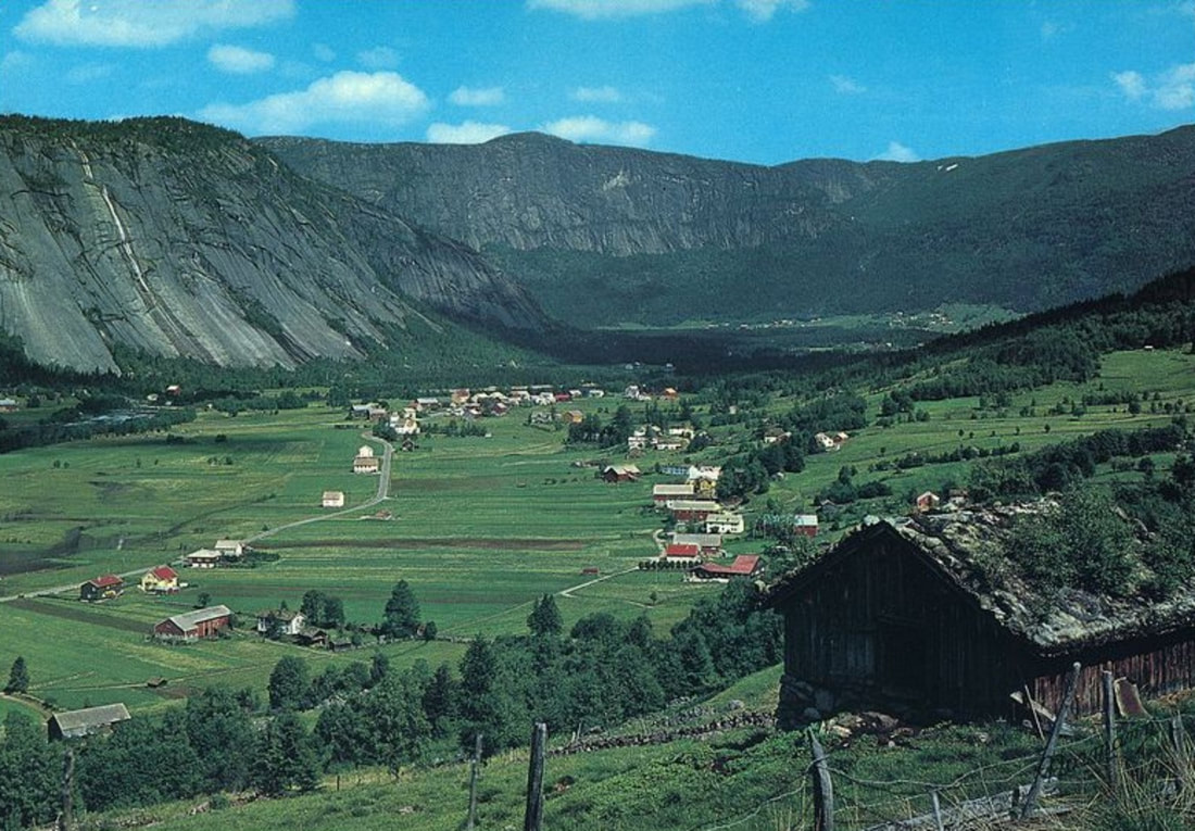
Valle is the administrative centre of Valle municipality in Agder county, Norway. The village is located in the Setesdal valley, along the river Otra. The village lies along the Norwegian National Road 9, about 99 miles north of the city of Kristiansand. The 94-acre village has a population (2016) of 289 which gives the village a population density of 761 inhabitants per 1,970/sq miles.
|
|
|
Valle is a municipality in Agder county, Norway. It is located in the traditional district of Setesdal. The administrative centre of the municipality is the village of Valle. Other villages in Valle include Besteland, Brokke, Homme, Hovet, Rygnestad, Rysstad, and Uppstad.
Valle was established as a municipality on 1 January 1838 (see formannskapsdistrikt law). On 1 January 1902, the northern part of Valle (population: 476) was separated to become the separate municipality of Bykle. This left Valle with 1,720 inhabitants. |
|
On 1 July 1915, the southern district of Valle (population: 658) was separated to form the new municipality of Hylestad. This left Valle with a population of 1,051.
The municipality (originally the parish) is named after the old Valle farm (Old Norse: Vollr), since the first Valle Church was built there. The form of the name is the genitive case, from the common expressions Vallar kirkja (church) and Vallar sókn (parish).
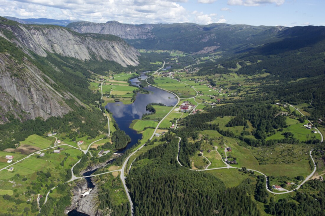
Valle is separated from the neighbouring valleys in the east and west by the large Setesdalsheiene mountain plateaus. Before the valley was linked by road to Kristiansand in the 1840s, people routinely traveled east and west across these moorlands. The highest point is the 1,418-metre (4,652 ft) tall Skammevarden. Other high mountains in Valle include Bergeheii, Skjerkenuten, Svarvarnuten, and Urddalsknuten.
The high mountains are the starting points for several large rivers including the Kvina and Tovdalselva. Several large lakes are also located in Valle including Botnsvatnet, Kolsvatnet, Rosskreppfjorden, Store Bjørnevatn, Straumsfjorden, and Øyarvatnet. The Hallandsfossen and the Gloppefossen are two larger waterfalls in Valle.
There are two central population centres in the municipality: Valle and Rysstad. The village of Valle is the site of the municipal administration and Rysstad was the site of the municipal administration in the old municipality of Hylestad.
The Hylestad stave church, constructed in the 12th century in Setesdal was demolished in the 19th century. Its portal, with several carved scenes illustrating the legend of Sigurd Fåvnesbane (Sigurd the Dragon-slayer), is on display at University Museum of Antiquities in Oslo (Universitetets Oldsaksamling, Historisk Museum, Oslo). Sigurd's slaying of Fafnir with his sword Gram is described in the Prose Edda of Snorri Sturluson and the Volsunga saga as well as alluded to in Beowulf and Njáls saga.
Rygnestadtunet is a historical family farm in Rygnestad, built by Vonde-Åsmund (Åsmund the Evil) in the mid-1500s. Today, it is an open-air museum that is part of the Setesdal Museum. The farm was sold to museum by Gyro Rygnestad and her family in the 1920s. Today, it is represented to visitors exactly as it was in 1919. Grave findings around the farm indicate that the site was settled as early as 900 AD. Another farm museum in Valle is Tveitetunet. There are also several old silver smithies and barns that can be seen in Rysstad.
Historically, Valle was very isolated from other parts of Setesdal. To get from Valle to the Bykle area to the north, residents had to traverse the Byklestigen pass along the river Otra. The pass was a torturous trail up a steep cliff face. Until the 1870s, it was the only route to travel from Valle in the middle Setesdal valley to Bykle in the north. It runs above the river Otra and was the site of numerous accidents on the hazardous route. Today, the Norwegian National Road 9 passes through the mountain in a tunnel providing a fast, easy route north.
Between Valle in Setesdal on the western side of the mountains and Fyresdal on the eastern side, one finds a medieval trail over the high plateau that priests and bishops used in order to get between the counties of Agder and Telemark. This track is named Bispevegen ("Bishop's Road") and every year a march called "Bispevegmarsjen" ("The Bishop's Road March") starts at Kleivgrend in Fyresdal.
The municipality (originally the parish) is named after the old Valle farm (Old Norse: Vollr), since the first Valle Church was built there. The form of the name is the genitive case, from the common expressions Vallar kirkja (church) and Vallar sókn (parish).
Valle is separated from the neighbouring valleys in the east and west by the large Setesdalsheiene mountain plateaus. Before the valley was linked by road to Kristiansand in the 1840s, people routinely traveled east and west across these moorlands. The highest point is the 1,418-metre (4,652 ft) tall Skammevarden. Other high mountains in Valle include Bergeheii, Skjerkenuten, Svarvarnuten, and Urddalsknuten.
The high mountains are the starting points for several large rivers including the Kvina and Tovdalselva. Several large lakes are also located in Valle including Botnsvatnet, Kolsvatnet, Rosskreppfjorden, Store Bjørnevatn, Straumsfjorden, and Øyarvatnet. The Hallandsfossen and the Gloppefossen are two larger waterfalls in Valle.
There are two central population centres in the municipality: Valle and Rysstad. The village of Valle is the site of the municipal administration and Rysstad was the site of the municipal administration in the old municipality of Hylestad.
The Hylestad stave church, constructed in the 12th century in Setesdal was demolished in the 19th century. Its portal, with several carved scenes illustrating the legend of Sigurd Fåvnesbane (Sigurd the Dragon-slayer), is on display at University Museum of Antiquities in Oslo (Universitetets Oldsaksamling, Historisk Museum, Oslo). Sigurd's slaying of Fafnir with his sword Gram is described in the Prose Edda of Snorri Sturluson and the Volsunga saga as well as alluded to in Beowulf and Njáls saga.
Rygnestadtunet is a historical family farm in Rygnestad, built by Vonde-Åsmund (Åsmund the Evil) in the mid-1500s. Today, it is an open-air museum that is part of the Setesdal Museum. The farm was sold to museum by Gyro Rygnestad and her family in the 1920s. Today, it is represented to visitors exactly as it was in 1919. Grave findings around the farm indicate that the site was settled as early as 900 AD. Another farm museum in Valle is Tveitetunet. There are also several old silver smithies and barns that can be seen in Rysstad.
Historically, Valle was very isolated from other parts of Setesdal. To get from Valle to the Bykle area to the north, residents had to traverse the Byklestigen pass along the river Otra. The pass was a torturous trail up a steep cliff face. Until the 1870s, it was the only route to travel from Valle in the middle Setesdal valley to Bykle in the north. It runs above the river Otra and was the site of numerous accidents on the hazardous route. Today, the Norwegian National Road 9 passes through the mountain in a tunnel providing a fast, easy route north.
Between Valle in Setesdal on the western side of the mountains and Fyresdal on the eastern side, one finds a medieval trail over the high plateau that priests and bishops used in order to get between the counties of Agder and Telemark. This track is named Bispevegen ("Bishop's Road") and every year a march called "Bispevegmarsjen" ("The Bishop's Road March") starts at Kleivgrend in Fyresdal.
